- Demonstrate an understanding of the nature of GIS, its historical development, capacity, advantages and disadvantages.
- Capture spatial information using a range of data capture techniques, validate and document this information and integrate it into a spatially related database.
- Analyse relationships between spatial and aspatial entities using GIS and a range of cartographic and statistical techniques, and communicate this information using a variety of digital and analogue.

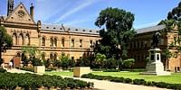
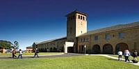
Flinders University, Adelaide, South Australia - Courses & Fees
Adelaide, South Australia
University Public CollegeBachelor (Applied Geographical Information Systems)
4 years
On Campus
English
Field of Study:
A$33,700/Yr
A$33,700 /Yr
Important Dates
Rolling aAdmissions after the deadline until all spaces are filled.
| Event | Start Date | End Date |
| Application Deadline For July 2023 Intake | Aug 1, 2022 | Jun 5, 2023 |
| Application Deadline For Feburary 2024 Intake | Aug 1, 2023 | Sep 30, 2023 |
Fees & Funding
Tution & Application Fees
| Year | Year 1 | Year 2 | Year 3 | Year 4 |
| Tuition Fees | A$33700 | A$33700 | A$33700 | A$33700 |
| Total Fees | A$33700 | A$33700 | A$33700 | A$33700 |
Living Costs
| Head | Avg Cost Per Year |
| Living Expenses | A$15269 |
Eligibility & Entry Requirement
- Completion of a CBSE School Certificate with an average of at least 65% in best 4 subjects (excluding local language).
- Completion of a ISC School Certificate with an average of at least 70% in best 4 subjects (excluding local language).
Ask your question
Similar Colleges You Might Be Interested In
- Similar Colleges
No Ratings Found!!
Follow
No Ratings Found!!
Follow

No Ratings Found!!
Follow
No Ratings Found!!
Follow

No Ratings Found!!
Follow
Australian National university test1
Canberra, Australian Capital TerritoryNo Ratings Found!!
Follow

No Ratings Found!!
Follow
Students also visited

University of AdelaideAdelaide, South Australia

Griffith UniversityBrisbane, Queensland

Queensland University of TechnologyBrisbane, Queensland
Western Sydney UniversitySydney, New South Wales

Torrens University AustraliaAdelaide, South Australia

Kaplan Business SchoolAdelaide, South Australia